Measurements Aloft Yield Improvements to AQ Emissions Estimates, Model…
In the world of regulatory ozone measurements, 2B Tech’s Personal Ozone Monitor is definitely punching above its weight!
Coming in at about a pound (~450 g), the versatile POM can be carried in a backpack, on a bicycle, aloft on balloons and drones, or even in the palm of a hand… all while providing Federal Equivalent Method measurements (EQOA–0815–227) over the range 0-500 ppb at a precision of 1.5 ppb.
Researchers at the University of California Riverside (UCR) put the POM to work aboard an unmanned aerial vehicle (UAV), to see how the real-world measurements of ozone levels during the UAV’s ascent and descent would compare with an air quality model’s estimates.

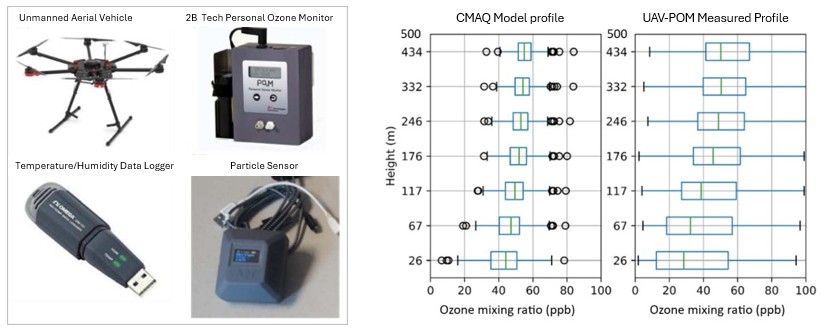
Left: Experimental system used in the study by Zhu et al. Right: Comparison of the median values of modeled and measured ozone abundances at various heights above ground level. Compared to the data, the model shows a more gradual gradient and higher values at the lower altitudes. Source: From Figures 1 and 7 of Zhu et al.
In total, the researchers gathered 321 vertical profiles from the surface to 500 meters above ground level in the early mornings and late afternoons from August to November of 2020. In addition to the 2-second ozone measurements of the POM, the data included measurements of particulate matter, temperature, and humidity.
Measurements of the vertical profiles of ozone showed discrepancies with the Community Multiscale Air Quality model (CMAQ), a model that’s widely used for compliance purposes. Ozone increased more steeply for the real-world data, largely because the measured values closer to the ground started off lower than in the model. Above about 150 meters in height, the model/measured values agreed more closely.
The authors explored various factors to bring the model into better alignment with the measured parameters. A key finding was that the NOx emissions that go into the model are probably too low, ultimately leading to inflated ozone predictions closer to the ground. Also by refining the model’s depiction of the atmospheric boundary layer, they achieved a closer match with actual measurements.
Air quality models are relied upon for decisions that affect the public’s health and have implications for the economy and businesses. This makes it all the more important to check that the models align well with real-world data, especially in complex pollution hotspots like Riverside. The POM is just the ticket for this crucial research!
——————————–
Assessing CMAQ Model Discrepancies in a Heavily Polluted Air Basin Using UAV Vertical Profiles and Sensitivity Analyses , Z. Zhu, K. Do, C.E. Ivey, and D.R. Collins, Environmental Science: Atmospheres (2024) 4, 1051.